CHEVRON AUGMENTED REALITY
Now available on Android…. Works best in Cherbourg.
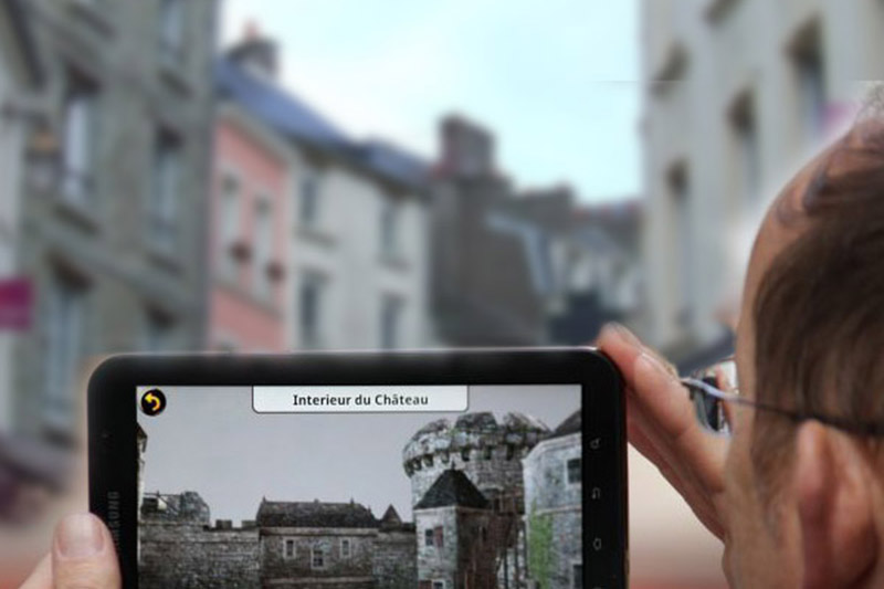
“Chevron” is our codename for an AR Project ongoing in France. Project Whitecard programmed this augmented reality application with partners Biplan that allows visitors to view the old castle as it once was.
A Q&A session follows:
Why did you choose to recreate Cherbourg of the seventeenth century?
“As part of events commemorating the 100th anniversary of Normandy,” says Lionel Guillaume, Agency Biplan audiovisual production, created by Antoine Allain 26 years ago. The castle, of which there are only a few traces remaining, marked the history of the city. “In 1689, Vauban wished to strengthen it: it was finally destroyed in order not to provide refuge to the enemy.”
What is augmented reality?
“It’s a process, using a Smartphone or a digital tablet, which allows viewing a virtual project in its real environment . By a compass and calculation of slope, the user can reveal the Chateau Cherbourg by medieval effect superimposed on the real. This technique significantly increases the value of visiting a city.”
How does it work?
It’s simple. Once located at one of the points provided, the user points his Smartphone as if he wanted to take a picture. The castle, moat, battlements and doors appear before the current buildings and streets. The 7 points are the swing bridge, parking Notre Dame, three locations in the Rue des Portes, and the statue Napoleon Street Square Tower.
Who is behind this project?
The agency Biplan, more accustomed to the documentary industry, wanted to diversify and has developed this project for 2 years. Biplan collaborated “with the Canadian company Project Whitecard , based in Winnipeg, as part of innovative French-Canadian collaboration.” The project has received support from the Regional Council, the Ministry of Culture, the European Union (ERDF Project) of Your Pole, OSEO, Normandy Tourism, and the National Research Council of Canada.
What is the historical basis?
The designers have used old engravings and images are based on the work of historians Laboratory Trame, University of Picardie, who specialize in medieval castles in northern France.
How will this project launch?
Available on Smartphone and on digital tablet devices by the end of summer, with free application. But also to the Tourism Office, a partner who will ensure the promotion and dissemination. Guillaume Hame explains: “We propose in three formats: on our website in late May, a downloadable mobile application and a kiosk at the Tourist Office. Biplan hopes to have the same type of controls for cities and foreign countries, including South America.
Information: the agency Biplane, 8 rue Bondor, tel. 02 33 93 60 00, and the Tourism Office, Wharf Caligny, tel. 02 33 93 52 02. Project Whitecard North America 1-855-269-0718.
Le Cherbourg médiéval en réalité augmentée
vendredi 15 avril 2011 Khal Shariff, de Project Whitecard, testent pour la première fois l’application en conditions réelles. L’agence vidéo Biplan et la société canadienne Project Whitecard ont créé une application Smartphone innovante. Et le château de Cherbourg apparaît… Pourquoi ? Comment ?
Pourquoi avoir choisi de recréer le Cherbourg du XVIIe siècle ?
« Au titre des événements commémoratifs du 1100e anniversaire de la Normandie », répond Lionel Guillaume, de l’agence de production audiovisuelle Biplan, créée par Antoine Allain il y a 26 ans. Le château, dont il ne reste que quelques traces, a marqué l’histoire de la ville. « En 1689, Vauban souhaitait le fortifier : il a été finalement détruit pour ne pas servir de refuge à l’ennemi ».
Qu’est-ce que la réalité augmentée ?
« C’est un processus qui permet, à l’aide d’un Smartphone ou d’une tablette numérique, de pouvoir visualiser dans son environnement réel un projet virtuel ». Par un système de boussole et de calcul d’inclinaison, l’utilisateur peut se délacer dans le Cherbourg médiéval par effet de surimpression sur le réel. Cette technique augmente sensiblement la valeur ajoutée de la visite d’une ville.
Comment ça marche ?
C’est simple. Une fois situé à l’un des points prévus, « l’utilisateur pointe son Smartphone comme s’il voulait prendre une photo ». Le château, les douves, les portes et les mâchicoulis apparaissent devant les immeubles et rues actuelles. Les 7 points sont le pont tournant, le parking Notre-Dame, trois endroits de la rue des Portes, la statue Napoléon et la rue Tour Carrée.
Qui est à l’origine de ce projet ?
L’agence Biplan, « plus habituée aux documentaires industriels », souhaitait se diversifier et a développé ce projet depuis 2 ans. Biplan a collaboré « avec la société canadienne Project Whitecard, basée à Winnipeg, dans le cadre de projets innovants franco-canadiens ». Le projet a reçu le soutien du Conseil régional, du Ministère de la culture, de l’Union européenne (Projet Feder), du Pôle Tes, d’Oséo, de Normandie Tourisme, et a coûté 150 000 €.
Quelles sont les bases historiques ?
Les concepteurs sont partis des gravures anciennes et se basent sur le travail des historiens du laboratoire Trame, de l’Université de Picardie, spécialisé dans les châteaux médiévaux du nord de la France.
Comment sera diffusé ce projet ?
Sur les Smartphones et tablettes dès la fin de l’été, avec application gratuite. Mais aussi à l’Office du tourisme, partenaire, qui en assurera la promotion et la diffusion. Guillaume Hamel, son responsable, s’explique : « Nous le proposerons sous trois supports : sur notre site internet fin mai, sur une application mobile téléchargeable et sur une borne interactive à l’Office du tourisme ». Biplan espère avoir des commandes du même type pour des villes et pays étrangers, notamment l’Amérique du Sud.
Renseignements : à l’agence Biplan, 8, rue Bondor, tél. 02 33 93 60 00, et à l’Office du tourisme, quai de Caligny, tél. 02 33 93 52 02.